
A cloud of tiny water droplets or ice crystals suspended in the air at or near the Earth's surface, reducing horizontal visibility to less than 1 kilometre (0.62 miles).
Fog is essentially a ground-level cloud. When water vapor in the air cools to its dew point — the temperature at which air becomes saturated — it condenses into microscopic droplets that remain suspended near the surface. The result is a thick, misty layer that can cut visibility to just a few metres, making it one of the most disruptive weather phenomena for aviation, road transport, and maritime operations.
Meteorologists classify fog as a form of low stratus cloud. The critical threshold that separates fog from mist is visibility: fog reduces it to under 1 km, while mist keeps it between 1 km and 2 km. Both are composed of the same tiny condensed droplets — it is only the density that differs.
How Does Fog Form?
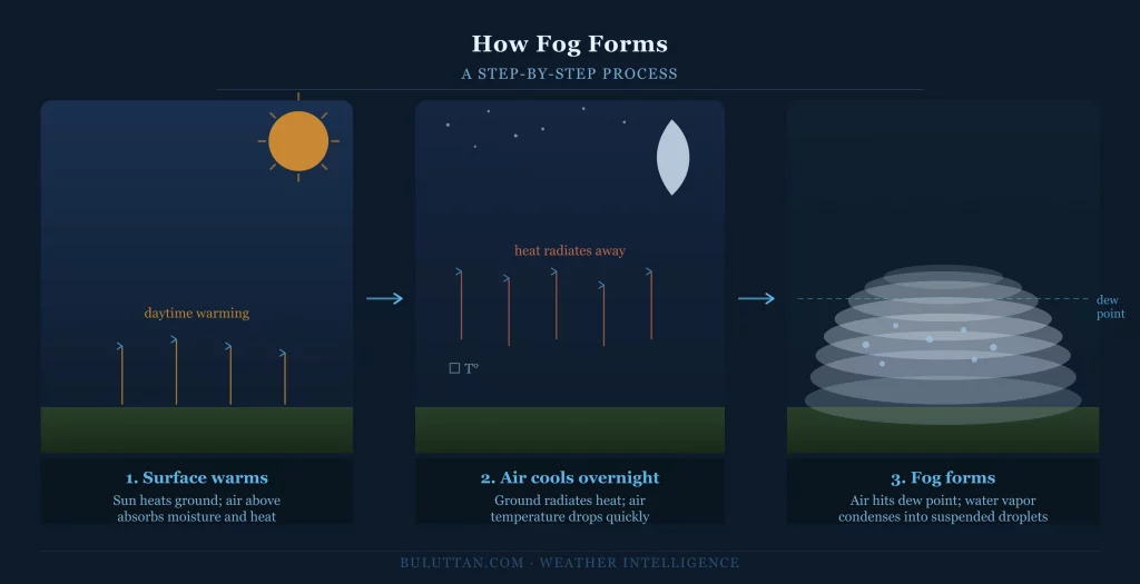
All fog formation comes down to one process: bringing air to saturation so that water vapor condenses near the surface. This can happen in several ways, but the most common involve either cooling the air or adding moisture to it until the dew point is reached. Once condensation begins, calm winds help keep the droplets suspended close to the ground rather than mixing them upward into the atmosphere.
Cooling of the Air
On clear nights with calm winds, the Earth's surface radiates heat rapidly into space. The air immediately above the ground cools by contact, eventually reaching the dew point and triggering condensation. This is why fog so often appears in valleys and low-lying areas — cold, dense air drains downhill and pools where it cools fastest.
Mixing of Air Masses
When two air masses with different temperatures and humidity levels meet — such as warm, moist air flowing over a cold sea surface — the mixed air can reach saturation and produce fog over wide areas. This mechanism is especially common over oceans and large lakes.
Addition of Moisture
Sometimes the air temperature stays constant but the amount of water vapor in the air increases — through evaporation from a warm water surface beneath cold air, for example. Once enough moisture is added, the air saturates and fog develops from below.
Types of Fog
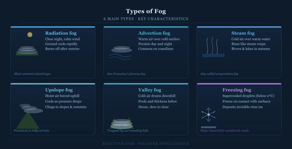
Radiation Fog
The most common type across continental regions. It forms on calm, clear nights when the ground cools rapidly through radiative heat loss, chilling the air above to the dew point. Radiation fog typically appears in low-lying areas and valleys, is densest just before sunrise, and burns off quickly once the sun heats the surface. It rarely extends higher than a few hundred metres above the ground.
Advection Fog
Forms when warm, moist air moves horizontally over a cold surface — most often a cold ocean current or snow-covered land — and cools to the dew point. Unlike radiation fog, advection fog can persist through the day and over large distances, making it a significant hazard for shipping and coastal aviation. San Francisco's famous fog is a classic example, driven by warm Pacific air flowing over the cold California Current.
Steam Fog (Evaporation Fog)
Occurs when cold air moves over a warmer water surface. Water evaporates rapidly into the cold air, saturating it almost immediately and producing rising wisps of fog that look like steam rising from a hot cup — which is exactly the same physical process. It is common on rivers and lakes in autumn, when water retains summer warmth but air temperatures have already dropped.
Upslope Fog
When moist air is forced up a hillside or mountain slope, it cools adiabatically — at a predictable rate as pressure decreases with altitude. If it cools enough to reach the dew point before the terrain levels off, fog forms along the slope and summit. Upslope fog is frequent in hilly and mountainous terrain, and it can persist for days when wind direction remains constant.
Valley Fog
A subset of radiation fog that is channelled and trapped by surrounding terrain. As cold air drains into valleys overnight, it accumulates in a layer that can reach tens of metres thick by morning. Valley fog is particularly dense and slow to clear because hillsides block the low-angle sun that would otherwise warm and evaporate it.
Freezing Fog
Occurs when fog droplets are supercooled — liquid below 0°C — and freeze on contact with surfaces such as roads, aircraft, and power lines, depositing a layer of rime ice. Freezing fog is especially dangerous for aviation and road travel because the ice it deposits is often invisible until it has already accumulated to a hazardous thickness.
Why Fog Matters
Fog is consistently ranked among the most economically costly weather phenomena. For aviation, even a brief period of dense fog can ground hundreds of flights, trigger cascading delays across a network, and force airlines into instrument-only approaches that require specific aircraft and crew certifications. For road transport and logistics, fog increases accident risk significantly — research consistently links low-visibility conditions to higher rates of multi-vehicle collisions on motorways. Port operations and maritime traffic are similarly vulnerable, with vessels required to reduce speed and sound fog signals when visibility drops below defined thresholds.
Beyond transport, fog plays a meaningful ecological role. In coastal and mountain ecosystems, fog interception by vegetation — a process called fog drip — can contribute significantly to local water budgets, sustaining plant communities through dry seasons when rainfall is absent.
Fog vs. Mist: What Is the Difference?
The distinction is purely one of density and the visibility it produces. Fog reduces horizontal visibility to under 1 km. Mist keeps visibility between 1 km and 2 km. Both are composed of the same suspended water droplets; mist is simply thinner. In everyday language the two words are often used interchangeably, but in meteorology and aviation the boundary at 1 km is a precise operational threshold with real consequences for flight rules and shipping regulations.
How Is Fog Forecast?
Accurate fog prediction remains one of the harder problems in operational meteorology. Because fog formation depends on the precise interplay of surface temperature, dew point, wind speed, soil moisture, and local terrain, even small errors in any of those inputs can shift a forecast from "patchy fog" to "dense fog advisory" — or miss the event entirely. Modern high-resolution numerical weather models, combined with surface observation networks and satellite-derived land surface temperature data, have improved fog forecasting considerably, but dense radiation fog in complex terrain still challenges even the best prediction systems.